
Remote sensing techniques for delimitation of burned areas in Tocantins through Landsat 8-TM digital image processing
DOI:
https://doi.org/10.20873/jbb.uft.cemaf.v8n1.silvaKeywords:
detection, brazilian savannah, fire useAbstract
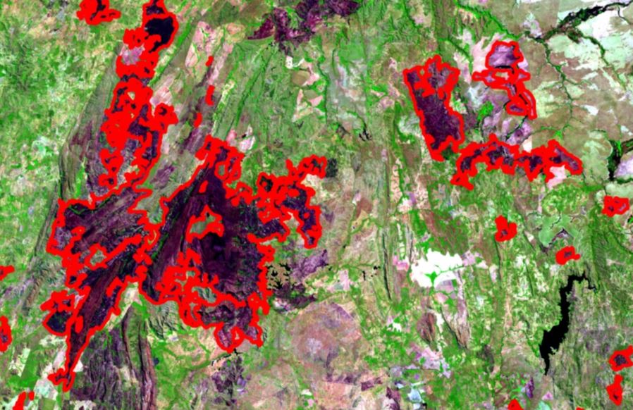
Methods of detection of burned areas are fundamental for a historical survey, as well as for the sizing of the effects produced by fire on the environment. In this sense, the objective of this work was to evaluate the procedure and methodology for the delimitation of burned areas by processing Landsat 8-TM images, during the period of greatest occurrence of hot flashes in three areas, which are located in the Eastern, Southern and Northern regions of the state of. Tocantins. To obtain the burned areas, image classification procedures were performed aiming at the class of interest (burned area). Initially, pre-processing was performed on the images: radiometric, atmospheric correction and projection system correction. After this step, the images were processed to obtain the Normalized Difference Vegetation Index (NDVI) in images before and after fire, called Im1 and Im2. After obtaining the NDVI, the images were compared pixel by pixel by subtracting the NDVI values, generating a difference image. Supervised rating shows better performance than unsupervised. The highest occurrences of burnt areas were in scenes 221/67 and 222/68 which is related to the climate, vegetation, occupation and land use of the regions covered by these scenes.
References
Ahern FJ, Goldammer JG, Justice CO. Global and regional vegetation fire monitoring from space: planning a coordinated international effort. Holanda: Kugler Publications, 303p. 2001.
Araújo FM, Ferreira LG. Satellite-based automated burned area detection: A performance assessment of the MODIS MCD45A1 in the Brazilian savanna. International Journal of Applied Earth Observation and Geoinformation, v. 36, p. 94-102, 2015.
https://doi.org/10.1016/j.jag.2014.10.009.
Boschetti L, Eva HD, Brivio PA, Grégoire JM. Lessons to belearned from the comparison of three satellite-derived biomas burnings pruducts. In: Setzer, A.; Morelli, F.; Lombardi, R. R; (Org.). O sensor MODIS e suas aplicações no Brasil. São José dos Campos: Editora Parêntese, 2007. cap. 28, p. 403-417.
Brasil. Ministério do Meio Ambiente. Mapeamento do uso e cobertura do cerrado: Projeto TerraClass Cerrado 2013. Brasília: MMA, 2015.
Carvalho LMT, Scolforo JRS. Inventário Florestal de Minas Gerais: Monitoramento da Flora Nativa. 2005-2007. Lavras: Editora UFLA, 318p. 2008.
Congalton RG. A review of assessing the accuracy of classifications of remotely sensed data. Remote Sensing of Environment, v.49, n.12, p.1671-1678, 1991.
Eva H, Lambin EF. Fires and land-cover change in the tropics: a remote sensing analysis at the landscape scale. Journal of Biogeography, v. 27, n. 3, p. 765-776, 2000.
https:// doi:10.1046/j.1365-2699.2000.00441.x.
Fanin T, Van der Werf GR. Relationships between burned area, forest cover loss, and land cover change in the Brazilian Amazon based on satellite data. Biogeosciences, v.12, p.6033-6043, 2015.
https:// doi:10.5194/bgd-12-8235-2015.
França H, Neto MBR, Setzer A. O fogo no Parque Nacional das Emas. Brasília: MMA, 140p., 2007.
Goulart AA, Morelli F, Setzer A. Focos de queimadas e incêndios detectados por satélites nas unidades de conservação do Cerrado no Mato Grosso em 2010. In: Simpósio Brasileiro de Geografia Física Aplicada, 14, 2011, Dourados. Anais. Mato Grosso do Sul: UFGD.
Hardesty J, Myers R, Fulks W. Fire, ecosystems and people: a preliminary assessment of fire as a global conservation issue. Fire Manage, v.22, p.78-87, 2005.
Instituto Nacional de Pesquisas Espaciais (INPE). Portal Programa Queimadas. 2016. Disponível em: Acesso 31 nov. 2019.
Libonati R, Camara CC, Setzer AW, Morelli F, Melchiori AE. An algorithm for burned area detection in the Brazilian Cerrado using 4 µm MODIS imagery. Remote sensing, v.7, p.15782-15803, 2015.
https://doi:10.3390/rs71115782.
NATURATINS - Instituto Natureza do Tocantins. Plano de Manejo do Parque Estadual do Jalapão–PEJ. Palmas: Naturatins, 2003. 204 p.
Ometto JP, Aguiar AP, Assis T, Soler L, Valle P, Tejada G, Lapola DM, Meir P. Amazon forest biomass density maps: tackling the uncertainty in carbon emission estimates. Climatic Change, v.124, n.3, p.545-560, 2014.
http://dx.doi.org/10.1007/s10584-014-1058-7.
Phulpin T, Lavenu F, Bellan MF, Mougenot B, Blasco F. USING SPOT-4 HRVIR and VEGETATION sensors to assess impact of tropical forest fires in Roraima, Brazil. International Journal of Remote Sensing, v.23, n.10, p.1943-1966, 2002.
https://doi.org/10.1080/01431160110076135.
Pivello V. The use of fire in the Cerrado and Amazonian Rainforests of Brazil: past and present. Fire Ecology, v.7, n.1, p.25-39, 2011.
https://doi: 10.4996/fireecology.0701024.
Secretaria do Planejamento Superintendência do Planejamento e Gestão Central de Políticas Públicas (SEPLAN). Diretoria de Zoneamento Ecológico-Econômico (DEZ). Base de dados geográficos do Tocantins, Palmas, SEPLAN/DEZ, 2015.
SEPLAN. Secretária de Planejamento do Estado do Tocantins. Atlas do Tocantins: subsídios ao planejamento à gestão territorial. 6º edição. Palmas. 2012. 80p.
Silva LAGC. Biomas presentes no estado de Tocantins. Brasília: Consultoria Legislativa, 2007. 10 p. (Nota técnica). Acesso em: 20 out. 2019. Disponível em: <https://goo.gl/ENNyjd>.
Xu R, Wunsch ID. Survey of clustering algorithms. IEEE Transactions on Neural Networks. v.16, n.3, p.645-678, 2005.
Published
How to Cite
Issue
Section
License
Copyright (c) 2024 - Journal of Biotechnology and Biodiversity

This work is licensed under a Creative Commons Attribution 4.0 International License.
Authors who publish with this journal agree to the following terms:
Authors retain copyright and grant the journal right of first publication with the work simultaneously licensed under a Creative Commons Attribution License (CC BY 4.0 at http://creativecommons.org/licenses/by/4.0/) that allows others to share the work with an acknowledgement of the work's authorship and initial publication in this journal.
Authors are able to enter into separate, additional contractual arrangements for the non-exclusive distribution of the journal's published version of the work (e.g., post it to an institutional repository or publish it in a book), with an acknowledgement of its initial publication in this journal.
Authors are permitted and encouraged to post their work online (e.g. in institutional repositories or on their website) prior to and during the submission process, as it can lead to productive exchanges, as well as earlier and greater citation of published work (Available at The Effect of Open Access, at http://opcit.eprints.org/oacitation-biblio.html).